
The Subway from the Left Fork Trailhead
A detailed guide to hiking The Subway in Zion National Park from the Left Fork Trailhead. Learn about the challenging 8-mile round trip, route finding, and the incredible features like Archangel Falls and The Crack.
I had heard from a few people this hike was tough and I can now confirm this personally. If you decide to take this hike make sure you arrive early in the morning because the hike will take you most of the day to complete. It's around an 8 mile round trip with a lot of route finding and bouldering along the way.
You start at the Left Fork Trailhead parking lot and soon drop approximately 400 feet down a fairly steep incline to the river below. This section has loose stone and can be slick so take your time getting to the bottom. Once you are in the riverbed follow the tracks in the sand as best you can. There is no set trail but most of the route is obvious from the footprints.
You will be crossing the river multiple times and the rocks you will be standing on are rounded from the river and covered with sand from the earlier visitors so be careful, I saw someone take a nasty spill off of one of these rocks and the only thing that saved him was his backpack kept his head from hitting the large rock behind him. This section of the trail isn't the most scenic but a good hike nonetheless. It will seem like this bouldering and route finding goes on forever because it does go on for quite a while but keep going the best is yet to come.
After about 3 miles of hiking through boulders you will come to a section of flat wide stair step waterfalls. From here on it is more difficult if not impossible to avoid walking in the water. One note of caution this area is very slick so watch your step. I saw more than one person lose their footing and then have trouble getting back to their feet; it feels like ice in some sections. This is also the area where the scenery becomes incredible. The first major feature you come to on this hike is known as Archangel Falls, a beautiful dark brown set of staircase drop-offs that the water flows over. Utah's slot canyons offer many spectacular waterfall destinations, including the iconic Lower Calf Creek Falls.
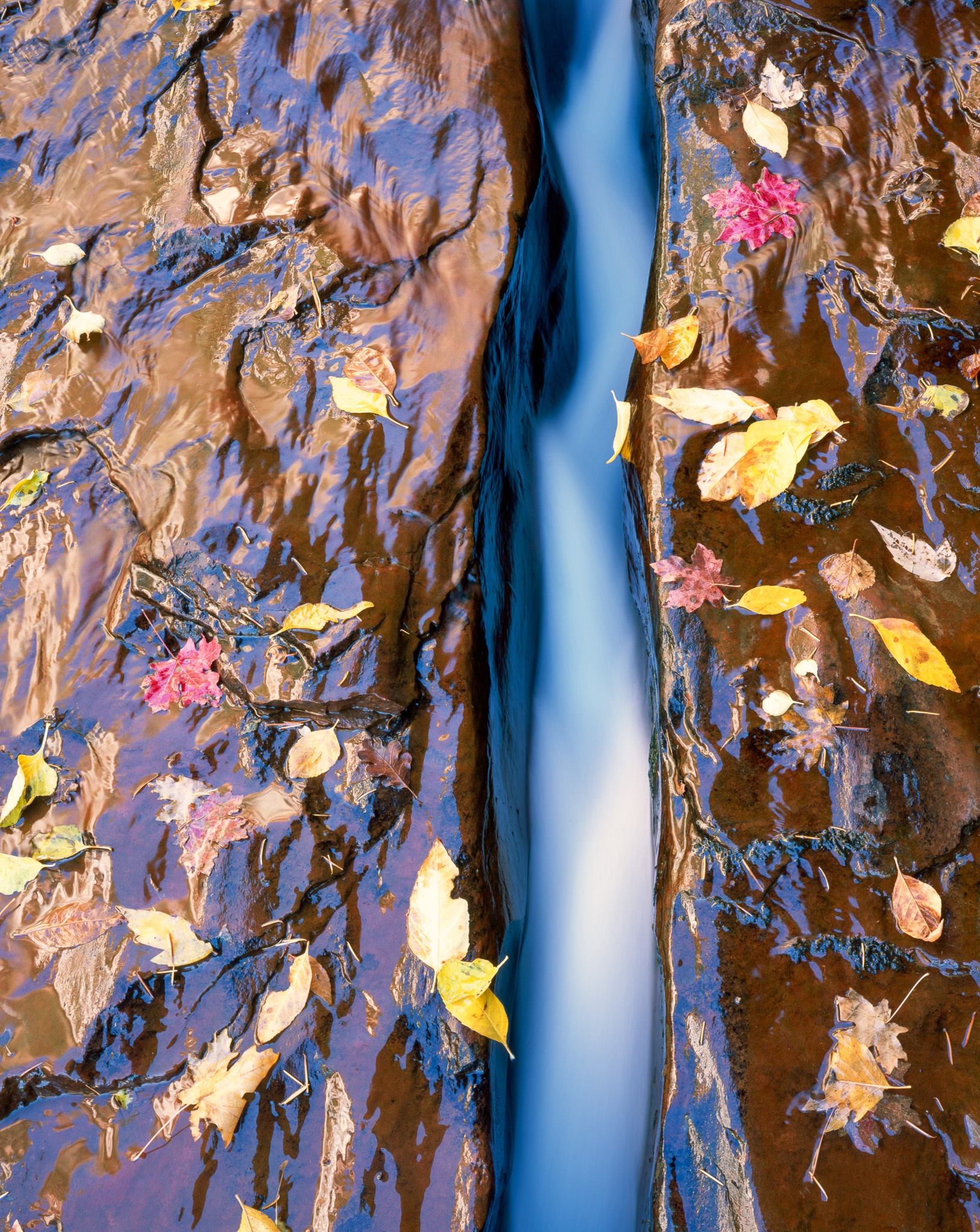
The Crack - A unique narrow canyon feature with fallen autumn leaves
The next major feature you come to is simply known as the crack for obvious reasons. In the fall the sides of the crack are littered with fallen leaves from upstream. This is not only an amazingly unique feature but very photogenic one as well. Using a polarizer you can get multiple different looks from the same composition so take your time and play for a bit here.
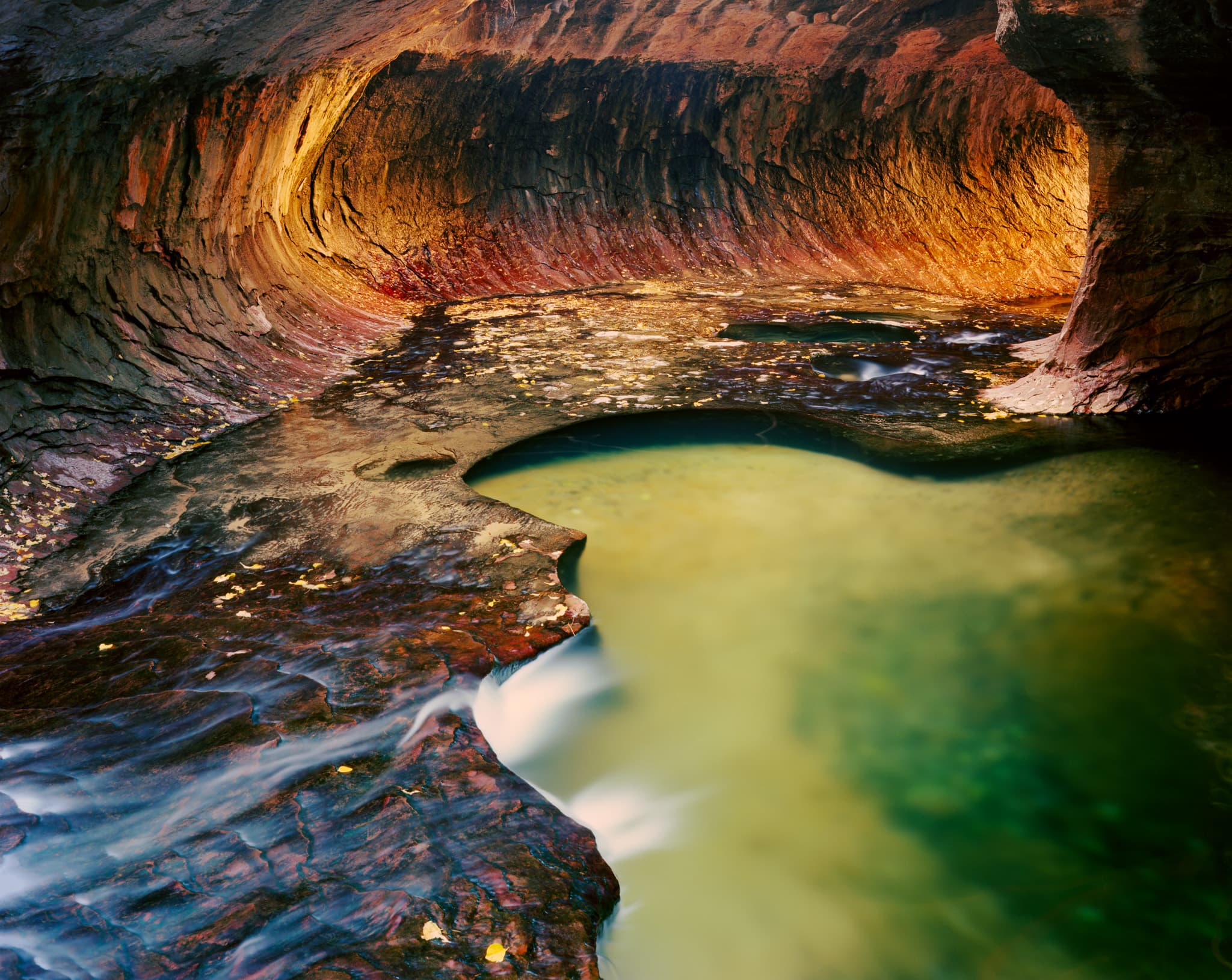
Next we come to the main attraction. After leaving the "Crack" you follow the right bend in the river that leads up hill and into the almost cylindrical section known as "The Subway". Follow the tube up and to the left for the best view. There is another slick uphill section even though it is only about 4 feet high, I saw a couple of people slip on the way up and slide on their butts on the way down to be safe.
I noticed the people with the rented canyoneering shoes had better traction than us with regular hiking boots so that may be a good idea if you are concerned with slipping. One person was wearing the Yaktrax traction devices and wasn't having any trouble getting around. I said "I thought those were for ice" he replied simply "This is ice!". My concern with this solution is it may cause damage to the rock in the subway though I didn't notice any damage from him.
After spending some time in this area it's time to make your way back to your car. Don't wait too long before heading back because you don't want to be trying to find your way out after dark. The hike is the same as the way in obviously but you don't want to miss the trail out of the riverbed up to the trail head. It is marked with cairns and sticks but when you are hiking things start looking the same in the boulders.
Once you find the river exit the next part is probably the hardest, mostly because by this time you have hiked at least 7 miles and now you are faced with a steep uphill climb of around 400 feet. I know this doesn't sound too bad but trust me it's a killer.
The Subway is one of many incredible photography locations in the park. For a complete overview of Zion's best spots—from the Narrows to Angels Landing—check out my Zion National Park Photography Guide. You can also browse my Zion photography gallery to see prints from this area.
Explore Related Photography
Enjoyed this article?
Subscribe for more photography stories, techniques, and exclusive behind-the-scenes content.
Related Posts

Grand Canyon Photography Guide: Best Spots, Light & Timing
The famous south rim overlooks are worth making. But the Grand Canyon images I keep coming back to came from a remote western overlook that requires 60 miles of unpaved road to reach — and from the North Rim in October, when the crowds are gone and the canyon light gets serious.

Best Places to Photograph Snow-Covered Mountains in Winter
Winter transforms mountain landscapes in ways no other season can. Where to go, when to go, and what to expect — from Yosemite's granite walls under fresh snow to Zion's red canyon in a storm.

Analog Landscape Photography: Why Film Still Makes Sense in 2026
Most photographers who've tried 4x5 large format film don't go back to digital for their serious landscape work. Here's the honest case for shooting analog in an era when you have no practical reason to.
Tags

Marty Quinn
Large format film photographer based in Phoenix, Arizona. Shoots on 4x5 Arca-Swiss view cameras across the American Southwest — Utah, Arizona, Death Valley, and the Colorado mountains. 25+ years behind the lens. Published in Outdoor Photographer magazine (The Last Frame, June 2008). About Marty →